Quick summary: Learn how geo mapping for rubber exporters in Malaysia enables EUDR compliance through GPS polygon mapping, traceability, and accurate supply chain data validation.
The EU Deforestation Regulation (EUDR), effective December 30, 2024, requires that all rubber and rubber-derived products entering the EU market be provably deforestation-free.
At the core of this requirement lies precise geolocation: GPS polygon mapping of every plot of land where the commodity was produced.
Geo mapping for rubber exporters in Malaysia is becoming a critical capability, enabling accurate data capture, validation, and compliance at scale particularly across a mix of smallholders and estate plantations.
This guide walks through each element of that process.
Regulation (EU) 2023/1115, commonly referred to as the EU Deforestation Regulation (EUDR), entered into force on June 29, 2023, with mandatory compliance deadlines beginning in late 2024.
It targets seven high-deforestation commodities:
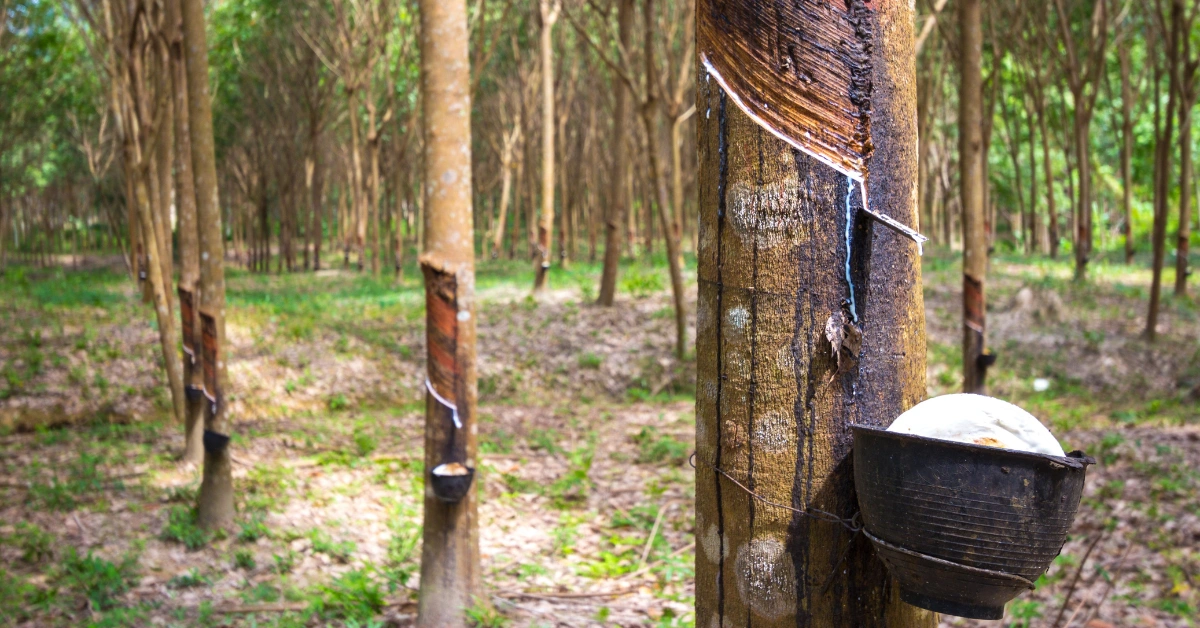
Malaysia being a key global supplier of rubber and rubber-based products must ensure its exports meet strict traceability and deforestation-free requirements to maintain access to EU markets.
Operators and traders placing Malaysian rubber on the EU market must demonstrate three key conditions before export:
• No Deforestation
Rubber must not be sourced from land deforested after December 31, 2020.
• Legal Compliance
Production must comply with all relevant Malaysian laws, including:
• Due Diligence
A formal due diligence statement must be submitted through the EU information system, supported by verifiable and auditable data.
Article 9 of the EU Deforestation Regulation (EUDR) makes geolocation mandatory and non-negotiable.
For land-based commodities like rubber, exporters must provide precise geographic coordinates in the form of GPS polygons for every plot of land where the rubber was produced.
In Malaysia, this requirement is particularly important due to:
| Requirement | Specification |
|---|---|
| Coordinate type | GPS polygons (lat/long pairs forming a closed boundary) |
| Accuracy standard | Parcel-level, sufficient to verify against satellite forest-cover data |
| Cut-off date | December 31, 2020 (forest cover must be intact at this date) |
| Format requirement | GeoJSON or compatible geospatial format |
| Linked documentation | Due diligence statement referencing coordinates |
| Submission system | EU TRACES / dedicated EUDR IT platform |
To comply with EUDR, Malaysian rubber exporters must collect and submit:
Malaysia’s rubber export story is increasingly about value-added products, market diversification, and downstream capability rather than just natural rubber volume. Recent data show natural rubber exports remain active and China is still the key destination, but the country’s real strength is in processing, especially gloves and other rubber products.
Malaysia’s total rubber exports were valued at about US$6.72 billion in 2024, up 22% from the previous year, while rubber exports in the first half of 2025 reached US$3.28 billion. For natural rubber specifically, exports were 58,755 tonnes in April 2022, with China taking 39.7% of shipments, and in August 2025 NR exports were 39,419 tonnes, with China still the main market at 39.1%. In December 2025, Malaysia exported 32,139 tonnes of natural rubber, down 12.7% from November, showing the sector’s month-to-month volatility.
Malaysia is not the world’s largest natural rubber producer, but it remains highly important in high-quality processing and export-linked manufacturing. China is the dominant buyer for natural rubber, while the United States, Germany, Finland, Egypt, and India are important secondary markets. That concentration means Malaysian exporters are exposed to demand swings in China, but they also benefit from scale, logistics, and established industrial buyers.
The export data point to a mixed picture: raw natural rubber volumes fluctuate, but the broader rubber sector is being supported by downstream products and stronger value-added trade. Industry commentary also suggests Malaysia is pushing into higher-value segments such as advanced rubber composites, conductive rubber, and sustainable rubber products, which could improve margins over time. This is important because natural rubber production has been under pressure, while export earnings are increasingly tied to processing strength rather than plantation output alone.
For buyers, Malaysia offers a more industrialized rubber supply base than many peers, which is attractive for quality-sensitive applications. For exporters, the main opportunity is moving further up the value chain, while the main risk is reliance on a few large markets and continued volatility in NR production and monthly shipments. Traceability and sustainability are also becoming more relevant as European and other regulated markets demand better origin and environmental documentation.
Under the EU Deforestation Regulation (EUDR), GPS polygon mapping is not just a regulatory requirement it is the technical backbone of deforestation verification.
For Malaysia’s rubber sector spanning both organized estate plantations and smallholder farms precise geolocation is essential to prove that rubber is sourced from deforestation-free land.
Without clearly defined plot boundaries, exporters cannot demonstrate compliance, putting EU market access at risk.
EU regulators and third-party verifiers rely on advanced satellite monitoring systems such as:
These platforms assess forest cover changes at the parcel level, which is only possible when accurate GPS polygon boundaries are available.
In Malaysia, where rubber production includes:
…a single GPS point is insufficient and non-compliant.
Here’s why polygons are required:
For Malaysian exporters, relying on point-based data creates significant compliance risks under EUDR.
According to EUDR technical guidance:
Understand EUDR geolocation requirements in detail. Learn how to capture accurate GPS polygons and ensure compliance.
Avoid common GeoJSON errors in EUDR submissions. Learn how to validate and correct your geolocation data.
Malaysia’s rubber supply chain presents a hybrid structure of organized estates and smallholder farms, which creates unique challenges for compliance with the EU Deforestation Regulation (EUDR).
While more structured than Vietnam or Indonesia, Malaysia still faces data standardization, traceability, and geolocation challenges especially when integrating smallholders into compliant supply chains.
Approximately 90% of Malaysia’s rubber production involves smallholders, many managing plots under 4 hectares, alongside large estates.
Rubber cultivation is concentrated in:
Key challenges include:
Malaysia’s terrain presents operational challenges for geo mapping:
Malaysia’s rubber industry includes:
This creates:
Even with better structure than some countries, end-to-end traceability remains a challenge.
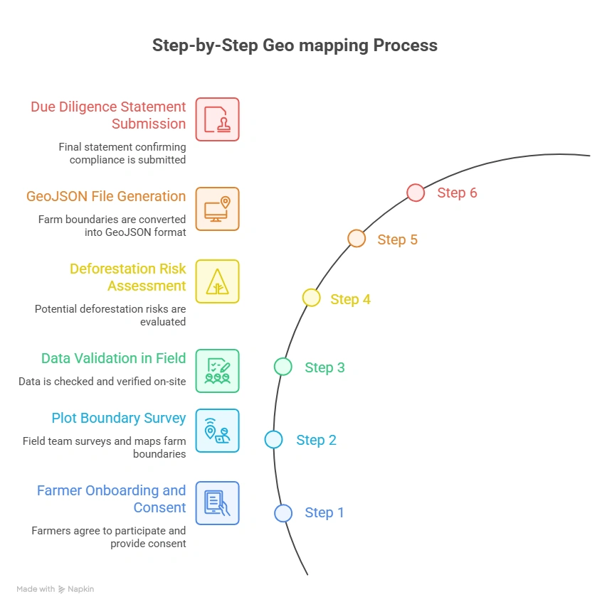
Below is a field-tested geo mapping workflow tailored for Malaysia’s rubber supply chain.
Before mapping begins, exporters must establish a compliant data collection framework:
Field agents use GPS-enabled smartphones or GNSS devices to capture polygon data.
Best practice protocol:
Validation should be completed immediately:
All plots must be screened against forest data:
Validated data must be exported in GeoJSON format (RFC 7946 compliant):
| Specification | Value |
|---|---|
| Geometry type | Polygon (Feature) |
| Coordinate system | WGS 84 (EPSG:4326) mandatory |
| Coordinate order | Longitude first, then Latitude (per GeoJSON spec) |
| Winding order | Exterior ring: counter-clockwise |
| Properties | farmer_id, plot_id, area_ha, crop_type, country, region |
| Encoding | UTF-8 |
| Validation tool | geojsonlint.com, QGIS geometry validator, or Turf.js |
Final compliance step:
Geo mapping for Rubber Exporters in Malaysia becomes seamless with TraceX EUDR solutions, enabling accurate GPS polygon capture, real-time validation, and end-to-end compliance management.
Data quality failures at the polygon level are the single most common reason EUDR submissions are flagged for review or rejected. Field teams and data managers should be trained to identify and fix the following errors:
| Error Type | Description | Impact | Fix |
|---|---|---|---|
| Self-Intersection | Polygon boundary crosses itself, creating a ‘bowtie’ shape. Occurs when field agent reverses direction while walking. | Fails GeoJSON validation; geometry engine cannot compute area. | Re-walk boundary; use QGIS Fix Geometries tool. |
| Unclosed Ring | First and last coordinate pair do not match. Polygon ring is not closed. | GeoJSON spec violation; most validators reject outright. | Append first coordinate to end of ring, or use auto-close in KoboToolbox. |
| Wrong CRS | Coordinates recorded in VN-2000 (Vietnam national projection) or UTM instead of WGS 84. | Coordinates displaced by hundreds of meters from true location. | Reproject to EPSG:4326 using QGIS or GeoPandas. |
| Reversed Winding Order | Exterior ring wound clockwise instead of counter-clockwise per RFC 7946. | Some parsers treat interior of polygon as exterior; area inversion. | Reverse coordinate array; QGIS ‘Rewind Polygons’ tool. |
| Coordinate Swap | Latitude and longitude values transposed (lat first, instead of GeoJSON spec’s lon first). | Plot placed in wrong hemisphere or ocean; immediate deforestation false-alarm. | Validate first coordinate: Malaysia lon ≈ 100–119°E; lat ≈ 1–7°N. |
| Spike Artefacts | One or more vertices are outliers caused by GNSS signal bounce under canopy. | Polygon area inflated; boundary bleeds into adjacent plots. | Remove outlier points; apply Douglas-Peucker simplification at 1m tolerance. |
| Duplicate Polygons | Same farm submitted twice with different farmer_id due to aggregator duplication. | Inflated area records; compliance review flags double-counting. | Spatial deduplication using PostGIS ST_Equals or Turf.js booleanEqual. |
| Overly Simplified Polygon | Only 3 or 4 vertices used for complex, irregularly shaped plots. | True boundary not captured; adjacent deforested land may be excluded or included. | Minimum 6–8 vertices for plots with non-linear edges; re-survey if needed. |
For Malaysia’s rubber exporters, compliance with the EU Deforestation Regulation (EUDR) is not just a documentation exercise it is a fundamental transformation of the supply chain.
The GPS polygon requirement sits at the core of this transformation, creating a verifiable link between plantation plots, forest-cover history, and exported rubber products entering the EU market.
Malaysia’s challenges are distinct integration of smallholders with estate plantations, inconsistent digital land records, and geospatial data accuracy across diverse terrains all present hurdles.
However, the path forward is clear. Exporters who invest in robust geo mapping infrastructure combining mobile data collection, spatial data management, deforestation risk screening, and compliance platform integration will not only meet EUDR requirements but also build a long-term competitive advantage in global markets.
The clock is running. Geolocation is the foundation. Build it right.
Explore the tools you need for EUDR compliance → Discover how Malaysian rubber exporters are using digital solutions for geolocation, traceability, and DDS submission.
Understand EUDR compliance requirements for rubber supply chains → Learn what exporters must do to ensure deforestation-free sourcing.
Learn how rubber exporters in Malaysia can meet EUDR requirements → Explore geolocation, traceability, and compliance workflows tailored to Malaysia.
Geo mapping for rubber exporters in Malaysia involves capturing GPS polygon coordinates of rubber farms and plantations to verify origin and ensure compliance with deforestation-free requirements under the EU Deforestation Regulation (EUDR).
Geo mapping is mandatory under EUDR because it enables authorities to verify that rubber is not sourced from land deforested after December 31, 2020, using satellite-based monitoring systems.
Exporters must collect:
Geolocation data is typically captured using:
Key challenges include:
Digital solutions help overcome these challenges through automated validation, risk scoring, and scalable traceability systems.